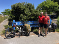
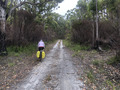
Diary of the Ride
Day 0 / Prelude: Friday, 21 December 2018
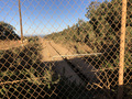
Flight from Sydney via Perth to Albany
As usual for our cycling (or bushwalking) trips, we plan to arrive at
the starting point the day before. Our Qantas flight from Sydney to Perth is
is several hours delayed (we had a similar experience when walking in the Pilbara
earlier that year, seems to be a pattern). As a consequence, we miss the
connecting flight to Albany; but Rex lets us rebook on the evening flight.
We miss out on dinner and grocery&fuel shopping, but at least we can
assemble the boxed up bikes in peace and get a decent night's sleep.
Day 1: Saturday, 22 December 2018
Albany → Denmark
distance=79km / riding time=6:10h / ascent=501m / max temperature=27°C
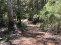
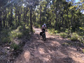
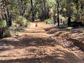
This section of the trail is ideal as a warm-up day: not too hilly,
never steep and the track surface is often very good, and never
difficult.
 The main challenge for us is in the timing: we need to do our shopping
in the morning (due to unplanned late arrival the night before), and
thus only start riding at 11 am, really too late for comfort given it
is a warm day and long stretches of the trail are on unshaded roads.
The main challenge for us is in the timing: we need to do our shopping
in the morning (due to unplanned late arrival the night before), and
thus only start riding at 11 am, really too late for comfort given it
is a warm day and long stretches of the trail are on unshaded roads.
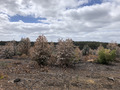
Nevertheless, we are enjoying a few treats along the way:
- Torbay is such a lovely spot in a forest opening, just right for a
short lunch break (some locals have the same idea and are preparing
for a wedding reception later in the day)
- Youngs Siding pops up an hour later with an offer we can't refuse:
ice cream:-)
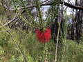
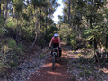
- The track into Denmark is along the beautiful Nornalup Heritage
Trail, at times almost totally overgrown with high grass and bush
(including Nuytsia floribunda and
 some long stretches under the shade of the forest canopy
along the ocean coast.
some long stretches under the shade of the forest canopy
along the ocean coast.
At 5pm sharp, tired but happy, we ride into town, check in at our
accommodation, 31 on the Terrace, where we had stayed two
years ago and had good memories of. This is early enough to top off on
groceries, relax and enjoy our room with balcony, test the culinary
offerings at the local pub and turn in just after sunset.
Day 2: Sunday, 23 December 2018
Denmark → Jinung Beigabup Campsite
48km / 5:36h / 876m / 22°C [total: 126km / 12h / 1,377m]
After a superb cup of coffee and a hearty breakfast at the Bibbulmun Cafe,
we push off at 8:30, clearly a lot earlier than the day before, and feeling less
anxious to about the heat. It turns out to be cloudless, sunny, but coolish day.
After a few kilometeres of sealed roads that take us South of Denmark,
we are treated to one of the visually most spectacular sections of the trail:
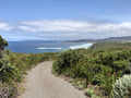 the re-aligned stretch South of the Highway, a very winding cycle path
along the tops of the cliffs taking us across to Greens Pool.
the re-aligned stretch South of the Highway, a very winding cycle path
along the tops of the cliffs taking us across to Greens Pool.
The second half of the day's trip takes us through undulating country
lined with farms/county houses and sprinkled in with some wineries.
Despite the moderate temperature, without any clouds it still feels
quite warm, especially on unshaded, steel uphill bits, of which there are a
few. There are also some badly corrugated roads and sandy patches. We play it
safe and stop at one of the houses to refill our water bottles, which
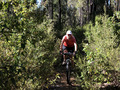
turned out a wise thing to do. For the last 3km we can leave the forest
roads behind and enjoy bike tracks through beautiful vegetation, though
some sandy parts are still posing challenges to us with our heavy packs.
One of us is a coeliac and, unsure about supplies along the way, we
carrying a fair bit of food. Our bikes are well over 40kg each.
We ride up to the campsite early afternoon.
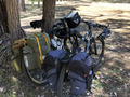
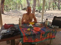
As soon as we get there, we attend to a few things in an order that
will soon become routine:
- set up our solar panels to recharge the phone batteries
- re-hydrate our thirsty throats, there are two water tanks at all Munda Biddi
campsites
- bicycle maintenance: lubricating chain & cassette
- read and write in the hut visitor book
- set up mattresses and sleeping bags
- cook dinner
- spend any remaining time reading
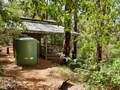
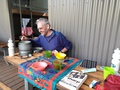
...and after such exhausting afternoon activities we are ready to drop
flat before sunset :-)
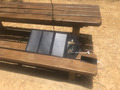
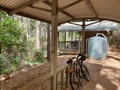
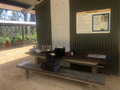
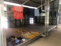
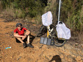
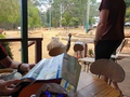
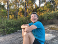
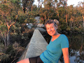
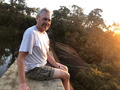
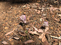
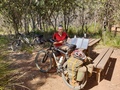
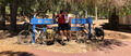
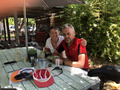
(Note: above pictures are taken from camps right across the trip.)

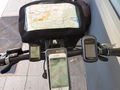 A little explainer (in pics) regarding the solar panels: this is Gernot's
bike ‘flight deck’ with 4 navigation tools; and his effort
at times to find the optimal exposure of the panels to sunrays:
A little explainer (in pics) regarding the solar panels: this is Gernot's
bike ‘flight deck’ with 4 navigation tools; and his effort
at times to find the optimal exposure of the panels to sunrays:
Conclusion: another good warm-up day—warm (but not hot) when
exposed to the sun, but also frequently with a light breeze.
Day 3: Monday, 24 December 2018
Jinung Beigabup Campsite → Booner Mundak Campsite
55km / 7:08h / 795m / 22°C [total: 182km / 19h / 2,172m]
We thoroughly enjoy the wonderful Munda Biddi campsite—the
first of many more to come—and feel reluctant to hurry up to leave
early. As we are not anticipating anything particularly challenging for
this day's section, we have a leisurely 8am start.
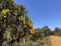
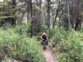
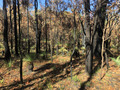
We start off on a beautiful bush track, amongst others lined with flowering
Beaufortia sparsa (a Callistamon, commonly known as
swamp bottlebrush) and banksias.
 Later the fire trails and roads take over, but not as bad as it could
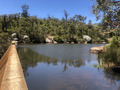
be. We are treating ourselves—deservedly—to a swim and
re-stock water at the pretty waterhole at Kent River bridge.
Later the fire trails and roads take over, but not as bad as it could
be. We are treating ourselves—deservedly—to a swim and
re-stock water at the pretty waterhole at Kent River bridge.
The last few km before the turnoff to the hut is a lengthy sand
stretch where pushing is unavoidable—this is once more hard work
with our heavily loaded bikes. Fortunately it is nowhere near as bad as two years
ago, when the sand was deeply dug up by fire trucks and on it was also very hot
(well over 30°C), making that section extremely hard; life is much easier this time. We are riding up to Booner Mundak Campsite at 3 o'clock.
Today, we are savouring the sun as the air is relatively cool. It
seems this is presently the only part of Australia that isn't sweltering,
large parts of the continent experience over 40°C that day.
Day 4: Tuesday, 25 December 2018
Booner Mundak Campsite → Walpole
59km / 7:26h / 1,000m / 24°C [total: 241km / 26h / 3,172m]
We get up fairly early and are ready to roll by 7:05. There is
much haze towards the East and a strong smell of fire in the air, to
the point we are getting worried that they might close the trail. But
eventually, we make it all the way to Walpole without incident.
Neither the park ranger we cross nor the fireys we meet in Walpole
make any particular mention, so apparently it's not an issue for us
after all, but the fire can't be far away from the parts of the trail
we have already passed.
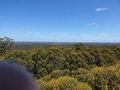
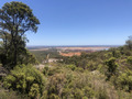
We are enjoying some changing surrounds: Compared to the first few
days, the trees are now getting noticeably taller. The Tree Top Walk
near the Valley of Giants Road provides some magnificent view over an
ocean of forest and bushland.
About an hour out from Walpole, we stop for lunch at the side of the Frankland
River. Enthusiastically jumping into the water, Gernot
forgets that he's pushed his sunnies onto his hat—never to be
found again in the murky river that quickly drops to 3m depth.
We roll into Walpole at half past 2, where we first
 get some emergency ice-cream injection, followed by checking out the
YHA. It had been recommended in one of the hut notes—and indeed, it
is a really nice place: conveniently located at the entry to the town,
comfortable and hospitable in bungalow-style arrangment with a huge
grassy courtyard and a generous communal kitchen. We then check out the town and are
pleasantly surprised that a cafe is open until 4pm, so we get some
takeaway food (with plenty of veggies & fresh salad) which we
later prepare in the hostel for dinner. The place is unlicensed and
the bottle shop is closed, so we're tee-totalling Christmas Day this year.
get some emergency ice-cream injection, followed by checking out the
YHA. It had been recommended in one of the hut notes—and indeed, it
is a really nice place: conveniently located at the entry to the town,
comfortable and hospitable in bungalow-style arrangment with a huge
grassy courtyard and a generous communal kitchen. We then check out the town and are
pleasantly surprised that a cafe is open until 4pm, so we get some
takeaway food (with plenty of veggies & fresh salad) which we
later prepare in the hostel for dinner. The place is unlicensed and
the bottle shop is closed, so we're tee-totalling Christmas Day this year.
Day 5: Wednesday, 26 December 2018
Walpole → Kwokralup Beela Campsite
31km / 2:58h / 567m / 25°C [total: 272km / 29h / 3,739m]
We leave Walpole quarter past nine, having to wait for shops to open:
this is the last town for a few days, so we need to re-stock
groceries. Gernot also gets some new sunnies (but no match for the nice
ones he lost).
 Given the sun is already fairly high up, we apprecite the tracks
taking us through beautiful, quite shaded areas. Swarbrick is lovely
place for a rest but far too early for lunch. Instead we defer
lunch until we arrive at the campsite shortly after midday. Hitting
camp early after an easy day riding gives us a chance to get some
extended rest and get ready for an early start. As we
scan through the trail log book, we come across our own entry from
23 Dec 2016, which was our last night on the trail that year.
Given the sun is already fairly high up, we apprecite the tracks
taking us through beautiful, quite shaded areas. Swarbrick is lovely
place for a rest but far too early for lunch. Instead we defer
lunch until we arrive at the campsite shortly after midday. Hitting
camp early after an easy day riding gives us a chance to get some
extended rest and get ready for an early start. As we
scan through the trail log book, we come across our own entry from
23 Dec 2016, which was our last night on the trail that year.
This site combines the (usually) beautiful setting with access to the Franklin,
with a great swimming hole. We think at the time that this is the best
hut of the Munda Biddi. We had by then been to all huts other than Karta Burnu
(turns out that one is nice but not quite a match for Kwokralup Beela).
Day 6: Thursday, 27 December 2018
Kwokralup Beela Campsite → Yirra Kartta Campsite
57km / 6:58h / 1,142m / 21°C [total: 329km / 36h / 4,881m]
 An early start, before 7am, on a cool, overcast morning.
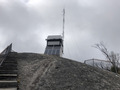 We take the detour to Mt Frankland Wilderness Lookout, well before any motorised
tourists hit it—the extra climb for this side trip is definitely worth it!
We take the detour to Mt Frankland Wilderness Lookout, well before any motorised
tourists hit it—the extra climb for this side trip is definitely worth it!
On the way back to the main trail it starts raining—we end up
with on-and-off rain and drizzle all day.
 This is the first (and only) time that we ever encountered rain while
riding the Munda Biddi! Being cold is more of an issue than being
wet—we can't imagine doing the ride in
winter, where cold and wet are what you expect daily!
This is the first (and only) time that we ever encountered rain while
riding the Munda Biddi! Being cold is more of an issue than being
wet—we can't imagine doing the ride in
winter, where cold and wet are what you expect daily!
The “summer route” near Fernhook Falls is closed due to bridge work, so
we have to take the “winter route” (i.e. road). Given the weather
we keep our lunch break at the falls short and don't even bother
walking to the falls. Quarter to three we reach the campsite.
This is our fourth time on the Munda Biddi. The first time in December
2006 we rode from Mundaring to the then Southern terminus, Collie, from where we
cycled on the road across to Banbury, where we took a train back to Perth.
The second time, December 2009, the trail ran up to to Nannup. We flew
into PER, rode from the airport to the city, took the bus to Busselton, rode
to Jarrahwood and camped there. Next day we rode to Nannup and back (without
packs), and the day after started the proper ride to Mundaring.
Two years ago we were planning to do the whole trail from South to North,
having flown to PER and on to ALH. Unfortunately, we only got to the
turn-off to this hut, Yirra Kartta, 300m back. Trudy lost her balance
when stopping abruptly, fell off the bike, and ended up with a broken
pelvis and collarbone. This resulted in a rescue operation involving a
ranger in a ute, an ambulance and a helicopter, and a complimentary
flight to Bunbury hospital, all on Christmas Eve. She spent the next 5
days there until they let her go on crutches, and we made our way back
to Sydney (after collecting the bikes and gear from the Walpole DPAR
office).
So, we're back, now breaking new ground, and hoping to finally do
the complete End-to-end Munda Biddi Trail!
Day 7: Friday, 28 December 2018
Yirra Kartta Campsite → Northcliffe
52km / 5:21h / 815m / 21°C [total: 381km / 42h / 5,696m]
We leave camp just after half past seven in light drizzle. Soon after
the clouds lift, handing us a nice excuse for a rest stop to pull out the
solar charger to re-charge our phone battery and to dry our spray jackets.
 Mid morning, Boorara Tree is a welcome, albeit minor, distraction from
a generally rather uninspiring section of the bike trail.
Mid morning, Boorara Tree is a welcome, albeit minor, distraction from
a generally rather uninspiring section of the bike trail.
Overall we make good progress, reaching town well before
1pm—ready to hit the pub, where they not only can feed and water
us, but also sleep us. Positive surprise is the explicit advertising
of GF food, including some delicious GF cakes :-) Steaks ordered
medium rare come out medium, which is close enough in the bush... A real surprise
is the small General Store that has a good selection of GF options.
Day 8: Saturday, 29 December 2018
Northcliffe → Pemberton
46km / 8:45h / 786m / 21°C [total: 426km / 50h / 6,482m]
We take it easy in the morning, enjoy breakfast at a cafe
 and ride out of town by quarter to nine in coolish conditions (overnight,
temperature dropped to circa 7°C). Today's section (between Northcliffe
and Pemberton) is definitely more interesting than most parts yesterday.
and ride out of town by quarter to nine in coolish conditions (overnight,
temperature dropped to circa 7°C). Today's section (between Northcliffe
and Pemberton) is definitely more interesting than most parts yesterday.
At around noon, disaster strikes on the last switchback going up to
Gloucester Tree, when Gernot's chain first buckles and then breaks,
literally 50m from the car park. Gernot fiddles with his chain tool,
without much success. Fortunately we had read in an
earlier log book about Mark Schmidt in Pemberton (0467-442-417) who is
a bicycle mechanic and likes to help trail riders. We are in luck,
he is able to come right away and can fix the chain. We
can then ride over to his place in town, where he has a proper
workshop and got both bikes back in great shape. Thank you, Mark!!!
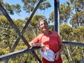 Before heading over to Mark's we climb the 58m spirals of the Gloucester Tree, of
the old fire-lookout trees scattered throughout the area, offering great views.
Before heading over to Mark's we climb the 58m spirals of the Gloucester Tree, of
the old fire-lookout trees scattered throughout the area, offering great views.
Our plan was to continue beyond Pemberton. However, Gernot's chain had delayed
us by 2.5h and it is now about 4pm, so we remain in town. Fortunately we get
a room at the YHA (the lady at the Information booth hat quipped that the town
is fully booked out). The hostel (only 3 rooms) is basic and somewhat quaint but clean
and tidy, and is run by friendly people. The pub we visit is not quite at par with
that in Northcliffe: the steak is ordered medium rare and served cremated.
Day 9: Sunday, 30 December 2018
Pemberton → Manjimup
83km / 10:02h / 1,346m / 29°C [total: 509km / 60h / 7,828m]
Leaving before 8am we make it to Quinninup by about 1pm, just as it started to
get really warm (finally some sun again!). We've hoped to have lunch at the local
pub, but that one is closed—in fact, Quinninup seems almost a ghost town
(some loud music notwithstanding); just a small park with toilets.
After a short picnic lunch break, we continue on to Warren River
Bridge, our planned camp for the night. However, after cooling down in
the river we decide to push on...
 ..and make it into Manjimup after a very long day, just before 6pm. We are rewarded:
even at this late hour we still get a room at the pub without problems (and with
en-suite :-)) and, of course, a cold drink. Turns out this is the only place on
the trail where our mandatory steaks are cooked to order: medium rare.
..and make it into Manjimup after a very long day, just before 6pm. We are rewarded:
even at this late hour we still get a room at the pub without problems (and with
en-suite :-)) and, of course, a cold drink. Turns out this is the only place on
the trail where our mandatory steaks are cooked to order: medium rare.
Day 10: Monday, 31 December 2018
Manjimup → Nannup
85km / 9:09h / 1,245m / 28°C [total: 594km / 69h / 9,073m]
As we wait for the shops to open to restock especially on picnic
lunch, we grab the chance to enjoy fabulous coffee at Southern
Roasters. It is past 9 by the time we are pushing off.
The cloudy morning and varied landscape allows for a most relaxed ride
to Karta Burnu hut. There, we break for morning tea to soak up the (as
usual) fantastic wilderness setting at these huts. The ride continues to be
very pleasant, much on old rail corridors, some quite overgrown, and a fair
bit of single track. Just to keep us in check, we also need to contend with
some rather boring stretches on Gold Gully Road. The long-advertised (since
mid-2018) prescribed burn south-west of Donnelly's Mill is actually burning
today; the air is quite bad from smoke in places. Given that the burn now
happed, it's hopefully only a matter of weeks until they re-open the original
section and remove a 5km by-pass of boring road. Yet, as far as
diversions go, this one has been still reasonably pleasant.
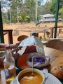
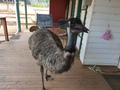
 At Donnelly's Mill we find a very welcoming shop-cum-cafe-cum-zoo: we get soup, cold drinks and ice-cream while emus keep us company on the deck.
It is way too early to camp here, but we are not sure whether we can make it all the
way to Nannup, not knowing what the track conditions are. So we stock up with lots
of extra water in case we need to camp along the way with out any water access.
The longish lunch break, however, has re-energised us well and keeps us rolling
along all afternoon, so that at 5pm we decide to dump the extra water and push on
the last 15km to Nannup. This turns out to be a good call, as from then on we ride
on sealed roads, mostly downhill, enjoying a good breeze in late afternoon light.
After an other long-ish day, we get to Nannup right after 6. The pup we are
staying at has really nice units, they look fairly new.
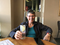
 Again we let others cook (Trudy had pasta for a change), and, to celebrate
closing the gap to earlier rides, we top it off with a bottle of champers—ah,
we also celebrate a little the past year that has treated us so well. As we take
ourselves to sleep, we wonder how we will cope with pub goers celebrating NYE,
but alas, the noise is limited and dies down eventually.
Again we let others cook (Trudy had pasta for a change), and, to celebrate
closing the gap to earlier rides, we top it off with a bottle of champers—ah,
we also celebrate a little the past year that has treated us so well. As we take
ourselves to sleep, we wonder how we will cope with pub goers celebrating NYE,
but alas, the noise is limited and dies down eventually.
Day 11: Tuesday, 1 January 2019
Nannup → Donnybrook
72km / 7:54h / 624m / 36°C [total: 666km / 78h / 9,697m]
We wake up to a gorgeous day. No need for any shopping, so we get underway
at 7:00 on the easy and enjoyable rail trail to Jarrahwood.
 We take our morning tea break at the Nala Mia hut and reminisce: It is here
where we started in 2009, when we first rode the Munda Biddi from South to
North. Nannup was the southern terminus then, which we did from here
as a day ride. This means we have now done the complete Munda Biddi,
although we're determined to do it end-to-end in one go this time!
So far, our ride is going quite well; in the past two days we've
completed what we had planned for three days. We are now expecting to
reach Mundaring (northern terminus) with three days to spare.
We take our morning tea break at the Nala Mia hut and reminisce: It is here
where we started in 2009, when we first rode the Munda Biddi from South to
North. Nannup was the southern terminus then, which we did from here
as a day ride. This means we have now done the complete Munda Biddi,
although we're determined to do it end-to-end in one go this time!
So far, our ride is going quite well; in the past two days we've
completed what we had planned for three days. We are now expecting to
reach Mundaring (northern terminus) with three days to spare.
We find that between Claymore Rd and Doonybrook the signposting is not up to
the normal (high) Munda-Biddi standard. It causes us no problem thanks to the GPS
track we had downloaded from the DPAW web site, else we'd be puzzled a few times.
Also, from Jarrahwood north are many signs that are quite faded, hard to tell
where they are pointing.
From Jarrahwood to Donnybrook there are a lot of sandy tracks, but mostly
reasonably ridable, although with extra effort. Recent stormy
 conditions have thrown some natural spanners in the works, providing us with some
true bush riding experience. Despite the distance (72km) it could have been a
fairly easy ride overall, were it not for a freak 35° day (note Trudy's
change to a lighter Jersey during the course of the morning); no wonder, we are
quite exhausted when we get into Donnybrook some time after 2.
conditions have thrown some natural spanners in the works, providing us with some
true bush riding experience. Despite the distance (72km) it could have been a
fairly easy ride overall, were it not for a freak 35° day (note Trudy's
change to a lighter Jersey during the course of the morning); no wonder, we are
quite exhausted when we get into Donnybrook some time after 2.
We are pleasantly surprised that the big IGA in Donnybrook is open on
NY Day, allowing us to do our shopping in the afternoon and thus be
ready for an early start the next day. Instead of the pub we opt for
the Motel next to the IGA, which turns out an excellent choice. Run by
a very friendly couple in their 60s, they give us a key to their shed
to lock up the bikes. And they have a pool! Perfect end to a very hot
day.
Day 12: Wednesday, 2 January 2019
Donnybrook → Nglang Boodja Campsite
48km / 4:27h / 788m / 24°C [total: 715km / 82h / 10,485m]
Turns out the 6:45 start from Donnybrook would not have been necessary: after
the previous, hot day, today is cool and we don't see the sun all day. While
this makes for relatively easy riding, it means that the battery of the phone
we use for navigation is almost flat, and there isn't sufficient light to
charge it with our solar panels. This means we'll have to ride without
the GPS track tomorrow. Also, it is a shame that we have the most
shaded hut just when we need it least!
The ride today hasn't been easy: not only lots of ups and downs, but
 also comprises the most boring parts of the Munda Biddi with almost
all on roads and a fair bit of it even sealed. Highlights were
Crooked Brook Forest and the few km south of Wellington Forest.
also comprises the most boring parts of the Munda Biddi with almost
all on roads and a fair bit of it even sealed. Highlights were
Crooked Brook Forest and the few km south of Wellington Forest.
In the end, we are glad we roll
 into Nglang Boodja Campsite well before lunch time (11:15), making it appear
as if we get to enjoy a full day's worth of camping with oodles of time
to read or just do nothing and simply relax.
into Nglang Boodja Campsite well before lunch time (11:15), making it appear
as if we get to enjoy a full day's worth of camping with oodles of time
to read or just do nothing and simply relax.
Day 13: Thursday, 3 January 2019
Nglang Boodja Campsite → Yarri
55km / 8:02h / 998m / 23°C [total: 770km / 90h / 11,483m]
We start in cool and overcast conditions to tackle the hill up from
Collie River. There was rain overnight (1mm recorded), but it didn't
impact the track. However, the 2km section marked “black/difficult”
is on often very eroded tracks, at times with pea gravel and mostly very
steep—in fact, utterly unridable with full touring gear, including
the well intended “serpentine” challenge designed specifically for
mountain biking (without luggage). The switchbacks are simply too steep and
narrow to ride them uphill on a heavily-loaded bike. We end up pushing our bikes
a lot, including on some “blue/intermediate”
sections further on. All up it takes us 2h from the hut winding down
to the river and back up to the top. Good thing it's early morning, so
it's cool and we are fresh, it would have been a killer late on a hot day!
Otherwise the riding is much easier than we remember from our 2006 and
2009 rides. We don't bother with Collie, which we know is a detour of almost
20km each way on boring, flat road—why would you do it? We had
stocked up well in Nannup and don't need supplies.
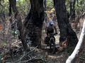
On one of the stretches we are guided around private property, where
 in part they had started a fairly sizeable plantation of some (for us not
further identifiable) shrub. While normally we think plantations are an eyesore
out here in the wilderness, in this case here it was in fact really sad, as all
the plants (from what we could see with no exception) are slain with some
disease such that the whole field is looking like a burnt lot.
in part they had started a fairly sizeable plantation of some (for us not
further identifiable) shrub. While normally we think plantations are an eyesore
out here in the wilderness, in this case here it was in fact really sad, as all
the plants (from what we could see with no exception) are slain with some
disease such that the whole field is looking like a burnt lot.
Our main concern of the day was whether the 5l of water we carry between
the two of us is sufficient, but we arrive at the campsite with 1.5l
to spare. The cool and partially cloudy day certainly helped—in
fact, if we ever have had a worry on the trip, it has been gauging the
amount of water we need to carry.
We arrive at the hut comfortably at 3pm; this one is one of our favourites on the
Munda Biddi. A lovely surprise finds us
as the hut still has the original log book, and we can find our entries of
29 Dec 2006 and 26 Dec 2009:-)
We've now covered 3/4 of the distance, 6 days to go!
Day 14: Friday, 4 January 2019
Yarri → Bidjar Ngoulin Campsite
83km / 9:56h / 1,196m / 25°C [total: 853km / 100h / 12,679m]
With a low of 5°C, this is the coldest night on the trip, but thanks dry
and warm sleeping bags, we wake very well rested, ready for a long day.
We kick off at our (these days) usual 7am. Early on, we are
treated to plenty of beautiful tracks and great variety of landscapes.
 Overall, this is much harder than the "easy/green" difficulty
level shown on the map (as commented earlier, these difficulty
levels are solely based on gradient, which is not really a useful
indicator given that on a heavily loaded bike, track condition is more
important than steepness). In summary, today's riding involves the
full gamut of thick pea gravel, deep sand, and badly eroded, steep
roads—to our frustration, often unridable with our loaded bike.
Overall, this is much harder than the "easy/green" difficulty
level shown on the map (as commented earlier, these difficulty
levels are solely based on gradient, which is not really a useful
indicator given that on a heavily loaded bike, track condition is more
important than steepness). In summary, today's riding involves the
full gamut of thick pea gravel, deep sand, and badly eroded, steep
roads—to our frustration, often unridable with our loaded bike.
As on our pervious trips, we stop at Lake Brockman Tourist Park for
brunch—it is such a refreshing treat! We also soak in the change
of scenery as we ride across the dam and along the lake.
10h after leaving our last hut in the morning we reach tonight's camp. While
the Munda Biddi huts are always a welcome sight, this one has a major drawback
making it probably the least desirable hut: the round-the-clock noise from
a nearby mining operation seriously degrades the wilderness experience.
Day 15: Saturday, 5 January 2019
Bidjar Ngoulin → Oakley Dam
45km / 6:08h / 828m / 31°C [total: 898km / 106h / 13,507m]
From Dwellingup to Oakley Dam the riding is wonderful: the surrounds are
beautiful and varied, often on single file tracks with firm, but springy forest
ground, the bush is softly brushing your arms and low tree canopy provides plenty
of shade—this is the kind of trail for which you ride the Munda Biddi!
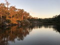
We reach Oakley Dam by about 2 and do what needs to be done first:
a long, relaxing swim to cool down and refresh! Ahh, how beautiful is
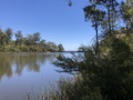
 this, just perfect for a hottish day! All afternoon we relax by the
water reading, or even simply dozing and doing nothing.
this, just perfect for a hottish day! All afternoon we relax by the
water reading, or even simply dozing and doing nothing.
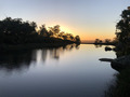
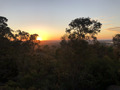
 The end of the day is capped off with a gorgeous sunset as the view from the
dam stretches over the escarpment to the west all the way to the coastline.
The end of the day is capped off with a gorgeous sunset as the view from the
dam stretches over the escarpment to the west all the way to the coastline.
We camp there for the night.
 While we carry a tent, we don't bother putting it up and instead
sleep under the stars. Unfortunately, clouds are soon moving in and stay
until the morning, preventing us from enjoying the full nightly sky.
While we carry a tent, we don't bother putting it up and instead
sleep under the stars. Unfortunately, clouds are soon moving in and stay
until the morning, preventing us from enjoying the full nightly sky.
Day 16: Sunday, 6 January 2019
Oakley Dam → Jarrahdale Township
62km / 10:58h / 1,196m / 35°C [total: 960km / 117h / 14,703m]
Anticipating a hot day we make very early start at 6. Just as
well we go by our gut instinct, as the BOM forecast is really off:
these folks must have looked out their window at 4am, have seen the
clouds and used the default algorithm that the whole day would
continue the same, which is what they put out as the actual
forecast. This was a complete miss: the clouds disolved as soon as the sun
got up, and the whole day ends up sunny and burning hot.
Even so, the day turns out to be less a challenge for its temperature
as much more one for the track conditions: This section is clearly the
worst to ride as the pea gravel (in itself is not much of a problem) is
mostly dug up very deep by fucking assholes on trail bikes, despite much of
the trail being in National Parks, where motorbikes are illegal. That it's all
marked “easy/green” on the map adds insult to injury! (These difficulty
indicators are worse than useless, they are soul-destroying! Were they
done by someone riding the trail on a motor bike?)
Additionally, the natural environment is rudely interrupted by the
mega-conveyor belts, that we need to negitiate—at least it is
 still really in the morning (6:30) for these shadeless stretches.
Just because it can, luck is against us as we face a puncture, albeit our
first and only one on the trail. We were hoping to get through completely without,
but a single puncture between two people on 1,100km isn't bad—brand-new,
2.2” tyres inflated to medium pressure certainly helped.
Before lunch time we reach Dandalup hut, which is beautifully
located, overlooking the escarpment with a view all the way to the
ocean. However, we really want to get out of the miserable dug-up track,
and decide to push on after a lunch break.
Persevering for 11 hours (clearly the longest and sadly the least
 rewarding day!), we roll up at Jarrahdale a little bit before 5. Of course, the
pub is still there to water and feed us; next door at the
“post-office” they sleep us!
rewarding day!), we roll up at Jarrahdale a little bit before 5. Of course, the
pub is still there to water and feed us; next door at the
“post-office” they sleep us!
Day 17: Monday, 7 January 2019
Jarrahdale → Carinyah Campsite
62km / 6:51h / 805m / 35°C [total: 1,022km / 124h / 15,508m]
We get under way bright and early, well before 7 to a leisurely 2h ride
 to Wungong hut—what a difference to yesterday's horror! While
not quite as enjoyable as yesterday's section was when we rode it 9 years ago,
today certainly mollified us and we are in the groove again!
to Wungong hut—what a difference to yesterday's horror! While
not quite as enjoyable as yesterday's section was when we rode it 9 years ago,
today certainly mollified us and we are in the groove again!
After a short morning tea stop we push on to Carinyah campsite where
we arrive circa half past 1. The second half of today's ride doesn't
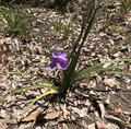
 let us down either—what a releif after yesterday's dismay—even
the flowers are out to greet us. While
easy to ride, today is relatively boring compared to what the previous
day, with much single track, should have been.
let us down either—what a releif after yesterday's dismay—even
the flowers are out to greet us. While
easy to ride, today is relatively boring compared to what the previous
day, with much single track, should have been.
By now we've clocked up over 1 thousand km, only 42km to go, and the
 last time staying at a Munda Biddi hut—which is also the first hut we
ever stayed on the Munda Biddi Trail. Makes us feel a bit melancholic.
last time staying at a Munda Biddi hut—which is also the first hut we
ever stayed on the Munda Biddi Trail. Makes us feel a bit melancholic.
Day 18: Tuesday, 8 January 2019
Carinyah → Mundaring Township
42km / 5:30h / 879m / 31°C [total: 1,064km / 130h / 16,387m]
 Savouring our last morning in the bush, we get under way by 7-ish.
Being one of the warm mornings, some of the steepest hills feel harder than
we think we remember this section from prior years.
Savouring our last morning in the bush, we get under way by 7-ish.
Being one of the warm mornings, some of the steepest hills feel harder than
we think we remember this section from prior years.
Still, we are savouring the last few moments of bush mountain biking. As we
get closer to civilisation around Jacoby Park and up towards
 Mundaring, we realise nevertheless how quiet and non-hectic it is out
here in regional Australia—exactly one of the features we are
looking for when we venture on trips like this one.
Mundaring, we realise nevertheless how quiet and non-hectic it is out
here in regional Australia—exactly one of the features we are
looking for when we venture on trips like this one.
As we are nearing the end of our trip, we are taking stock of our
incidents along the way and only come up with a very short list:
- 1 broken chain (thanks Mark Schmidt for fixing it!!!)
- 1 lost pair of sunnies
- 1 puncture
- 1 very minor issue that could be resolved with a cable tie
Nothing else!
Soon after 11 we roll up to Mundaring Sculpture Park—HAPPY,
even if somewhat exhausted, and relieved that we did the E-2-E Munda
Biddi with no mishaps and sooooo many wonderful memories!
Epilogue: Tuesday noon, 8 January 2019
Mundaring → Perth Airport
31km / 1:20h / - / 31°C
TOTAL: distance= 1,095km, time=131h, ascent=16,387m
After signing out from the Munda Biddi trail, we re-fuel at the recommended,
very charming Cafe Mojo.
 Shortly after midday we head down the escarpement, after fully inflating our
tyres to make best use of the smooth-sealed, downhill ride.
A last challenge is finding the way to the airport. All the street
signs, as well as Google Maps riding directions, lead to a freeway
with very definite no-cyclist signs. We keep riding through the
suburbs by gut-feel, until Google finally gives us usable directions.
Most of it ends up on minor roads, so the ride is relatively pleasant.
Shortly after midday we head down the escarpement, after fully inflating our
tyres to make best use of the smooth-sealed, downhill ride.
A last challenge is finding the way to the airport. All the street
signs, as well as Google Maps riding directions, lead to a freeway
with very definite no-cyclist signs. We keep riding through the
suburbs by gut-feel, until Google finally gives us usable directions.
Most of it ends up on minor roads, so the ride is relatively pleasant.
At the airport, we buy boxes, pack up our bikes and store them for
the night, as we have been able to reschedule our flights back to
Syndey for the next day (not without getting screwed by Qantas). Soon
afterwards, our Perth friend Marie picks us up and we spend a wonderful
evening with her and partner Stephen, a nice end to an exciting trip.
Return to main page of
Munda Biddi Trail Ride
© Gernot Heiser 2019.